Geospatial Web Harvester
Geospatial Web Harvester
Are you struggling to keep track of geospatial data sources? Searching through vast data resources manually is costly and time-consuming. Organisations using geospatial data in their operations face the challenge of cataloguing dynamic geospatial information to ensure data accessibility, quality, and operability. Geospatial data remains underutilized without efficient tools, impacting decision-making and operational efficiency.
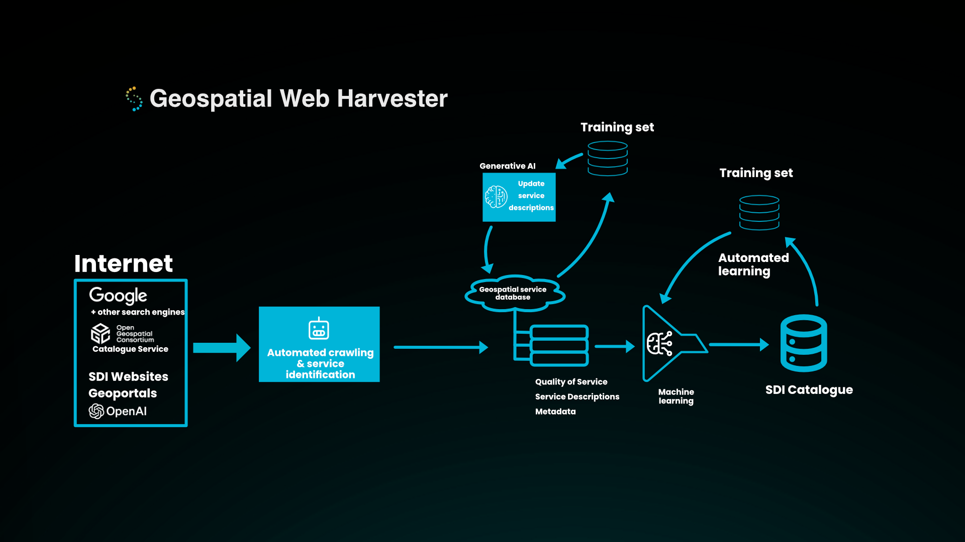
Meet Geospatial Web Harvester —an AI-powered tool designed to automatically search, categorise, evaluate, and catalog geospatial services for you.
For whom
Geospatial Web Harvester is designed for organisations that maintain huge data portals and use vast amounts of geospatial data in their operations, such as militaries, renewal energy companies, utility and grid operators, and meteorological institutes.
Key Benefits
-
Automated Search and Discovery
Finds relevant geospatial services from across the web.
-
Automated Categorization
Classifies services efficiently, reducing human effort with machine-learning.
-
Automated metadata improvement
Generates descriptive metadata, enhancing service descriptions and discoverability with generative AI.
Features and Capabilities
-
Automatic Catalog Generation
Automatically compiles catalogs for your specific use-case whether that is around a data theme, research field, specific area or location.
-
Intelligent Classification and Evaluation
Uses advanced machine learning to ensure the data meets your criteria.
-
Service Descriptions with Generative AI
Creates robust, insightful descriptions that make data accessible and understandable.
Case Studies
-
Trusted by Industry Leaders
Used by Natural Resources Canada to create and maintain the Canadian Data Catalogue and Arctic SDI Catalogue, ensuring data operability and accessibility across vast geospatial networks.

Spatineo has 14 years of experience in geospatial service analytics. We have the world's most extensive database of open geospatial services with service quality information. Not only do we know that these services exist, but we also know their uptime, standard compliance, and performance. Our database, Spatineo Directory, is a critical component of Geospatial Harvester. Spatineo Directory is collected from various sources on the Internet, such as Google, OGC catalogue service, and national geoportals, with a fully automatic intelligent software robot.
Book an introduction
Contact Us!
.jpg?width=150&height=200&name=Spatineo%20-%20JooWorks%20-%20Henkil%C3%B6kuvat0023%20(1).jpg)
Oskari Häkkinen
CEO
+358 45 127 1861
oskari.hakkinen@spatineo.com